


New survey points to the lasting impact of Hurricane Maria on marine environments in Dominica
CME Programme Press Release – Scientists from the National Oceanography Centre (NOC) have recently discovered large seagrass beds where coral reefs might have been expected off the Island of Dominica, likely due to damage caused by Hurricane Maria in 2017. The survey makes up a part of the UK’s Commonwealth Marine Economies Programme.
Dominica’s position in the Eastern Caribbean means it is highly susceptible to natural disasters. In 2017 Hurricane Maria (a deadly Category 5 hurricane) crossed the Island, severely damaging the coastline and its fishing community. Before the NOC’s recent study, there was no documentation on the extent of damage to the marine environment.
Working with the fisheries department of the Ministry of Blue and Green Economy, Agriculture and National Food Security, NOC scientists conducted a baseline marine environmental and topographic survey in areas that are renowned for their fishing and diving resources. The information collected will improve the marine spatial planning and management of these areas in the event of future natural disasters and will help mitigate the extent of the damage in 2017.
Scott Furssedonn-Wood, High Commissioner to Barbados & Eastern Caribbean, said: “Surveys like these provide invaluable scientific data that can help in understanding the damaging effects of climate events, which can help in mitigation efforts to protect vital ocean ecosystems and resources on which the people of Dominica depend for their livelihood.
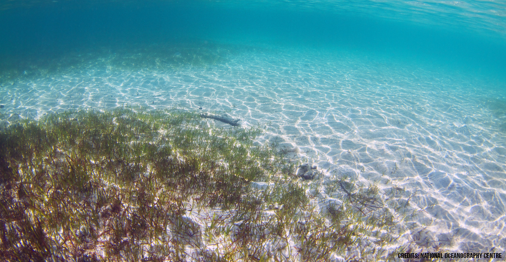
Using a small remote-controlled camera system, videos were captured of the seabed between five and 100 metres in depth to distinguish the environmental conditions for fish, seagrass, and coral. The survey revealed that a significant amount of sediment that originated from the coastline was covering the seafloor further offshore, while very large seagrass beds were found nearer to the shore than before. Although coral reefs were also detected in the survey, they were typically smaller than would normally be expected at those water depths.
Dr Tim Le Bas, a Marine Environmental Mapping Expert at the National Oceanography Centre, said: “Dominica is no stranger to hurricanes of such magnitude, so it’s uncertain how long it will take for the seafloor to fully recover. Habitat surveys such as this are therefore essential for understanding and monitoring seafloor evolution and can help officials to identify specific causes of damage to the marine environment.
“Throughout this project we worked closely with officers within the fisheries department in Dominica, enhancing their capabilities in marine habitat mapping so that they can continue to acquire and interpret this type of data in the future.”
Furssedonn-Wood added: “The data will also play a critical role in underpinning strategies by the Government of Dominica to plan for future severe weather events, given the country’s susceptibility to hurricanes. We welcome the UK’s commitment to helping vulnerable SIDS navigate climate challenges and to work with key agencies to build capacity.”
Funded by the UK Government, the CME Programme supports Small Island Developing States (SIDS) to better understand and utilise their marine resources, resulting in sustainable and growing marine economies that create jobs, drive national economic growth, reduce poverty, and ensure food security and build resilience.
About the Commonwealth Marine Economies Programme
Funded by the UK Government and led by the Foreign Commonwealth and Development Office, the CME Programme is supporting 17 Commonwealth Small Island Developing States (SIDS) in the Caribbean and Pacific in identifying the potential of, and developing, their marine economies in a sustainable, resilient and integrated way. The Programme promotes growth, innovation, jobs and investment whilst safeguarding healthy seas and ecosystems. In partnership with the SIDS governments, the Programme will develop and implement national Maritime Economy Plans to ensure the Programme leaves a lasting legacy.
The Programme has delivered world-leading expertise in marine science through its main delivery partners: the United Kingdom Hydrographic Office (UKHO), the Centre for Environment, Fisheries and Aquaculture Science (Cefas) and the National Oceanography Centre (NOC); and a team from Atkins with a mix of technical, institutional and regional experience are working in partnership with SIDS governments to support the development of bespoke Maritime Economy Plans, tailored to the national needs and priorities of each country. Find more information on the CME Programme here: https://www.gov.uk/guidance/commonwealth-marine-economies-programme.
Find more information about CME Programme activities in Dominica here: https://www.gov.uk/government/publications/commonwealth-marine-economies-cme-programme-dominica.
National Oceanography Centre
The National Oceanography Centre (NOC) is the UK’s leading institution for integrated coastal and deep ocean research. The NOC undertakes and facilitates world-class agenda-setting scientific research and technology development to understand the global ocean by solving challenging multidisciplinary, large scale, long-term marine science problems to underpin international and UK public policy, business and societal outcomes.
The NOC operates the Royal Research Ships James Cook and Discovery and develops technology for coastal and deep ocean research. Working with its partners, the NOC provides long-term marine science capability including sustained ocean observations, mapping and surveying; data management and scientific research and advice.