Weather systems and La Niña in the Atlantic
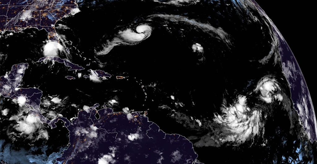
Paulette, Rene and Twenty are just 3 of the 6 weather systems being monitored by the National Hurricane Center in the Atlantic amid La Niña.
Hurricane Paulette
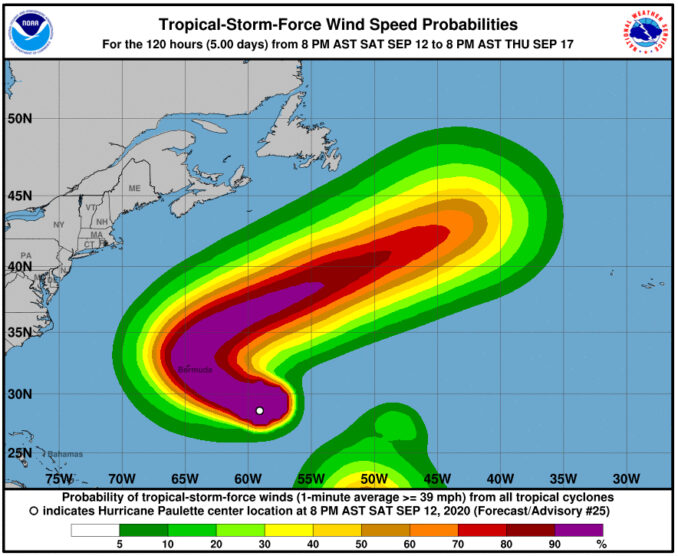
Hurricane Paulette could directly hit Bermuda by Monday and stirs up waves and rip currents on the U.S. East Coast.
A hurricane warning has been issued for Bermuda, which will likely see tropical storm conditions by late Sunday. Hurricane conditions are possible in the archipelago by Sunday night or early Monday. Damage is expected in Bermuda from strong wind gusts if Paulette makes a direct strike on the island.
The Bermuda Weather Service advises the public to be prepared and stay vigilant as Paulette is expected to bring heavy rain and storm surge that could cause flooding, especially in the coastal areas. Rainfall totals are expected to be in the 3 to 6-inch range.
In the 11:00 PM advisory issued by the National Hurricane Center, the center of Hurricane Paulette is located 615 km SE of Bermuda and is moving west-northwest near 14mph.
Swells generated by Paulette are affecting portions of the Leeward Islands, the Greater Antilles, the Bahamas, and Bermuda.
Paulette will also bring increased wave activity and the threat of rip currents to the U.S. East Coast.

Tropical Storm Rene weakens
Tropical Storm Rene weakens into a Tropical Depression and is now forecast to become a remnant low on Monday.
Rene is located 1895 km ENE of the northern Leeward Islands with maximum sustained winds of 30 mph and is posing no threat to any land mass.
TD Twenty forms
Tropical Depression 20 formed Saturday evening around 2000 miles east of the Lesser Antilles. There are no coastal watches or warning in effect.
Twenty is expected to intensify but will move northwestward into the open Central Atlantic over the next five days.
When this system becomes a tropical storm, it will gain the name “Teddy.” Then, it is expected to become a hurricane by Tuesday well east of the Caribbean. If this happens, it will be the earliest “T” named storm on record beating out an unnamed storm on October 4, 2005.
Tropical Depression 20 has formed in central tropical Atlantic. Forecast to become tropical storm tomorrow. If it gets named, it will be #Teddy. Current record for earliest Atlantic 19th named storm is October 4, 2005 (Unnamed). Unnamed storm in 2005 was added after the season. pic.twitter.com/EYgML5EYzA
— Philip Klotzbach (@philklotzbach) September 12, 2020
La Niña has begun – how does this affect the Atlantic?
The National Oceanic and Atmospheric Administration announced on Thursday that La Niña has begun and is expected to last through spring of 2021.
It’s here! Today NOAA declared that #LaNina conditions are now present. Read more at @NWSCPC: https://t.co/1SoztfCqpc pic.twitter.com/XuYf0npd6Q
— National Weather Service (@NWS) September 10, 2020
La Niña, Spanish for “little girl,” is a naturally occurring phenomenon in which sea surface temperatures across the central and eastern Pacific Ocean are cooler than average.
The phenomenon usually means a more active hurricane season in the Atlantic AND the possibility of more wildfires in the West Coast due to drier weather conditions.
“La Niña is not a good sign for the wildfire outlook,” said Stanford University climate scientist Noah Diffenbaugh
Colorado State University research scientist and hurricane forecaster Philip Klotzbach believes that La Niña will also mean hurricane season won’t ramp down in the fall as usual. Instead, there’s a greater chance that the Caribbean could produce powerful hurricanes late into the season, which officially ends Nov. 30.
“In a La Niña year, we can sometimes get nasty storms into November.”


